
Over hundred dead, hundreds more being treated for sun strokes. Almost 30 crore people across India are facing the brunt of the summer heat and shortage of drinking water.

The duo used their mobile phone to establish contact for their rescue, following which an NDRF team was roped in.

Central Statistics Office has come out with GVA to measure growth.
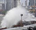
Several major cyclones have hit various parts of India over the last 10 years. Here is a look at the notable among them.

With conditions not favouring its progress, southwest monsoon is expected to hit the Kerala coast by June 4, three days after its normal onset date, the MET department has said.

Slight tremors of 3.1 magnitude were felt in the national capital region on Monday night. The slight-intensity quake occurred at 12:41 am and the epicentre was Delhi, an India Meteorological Department report said.

The current spell of weak monsoon over the country is likely to continue for the next five days, the India Meteorological Department (IMD) said on Wednesday.

The 'eye' or centre of the cyclone is estimated to be 15 km in spread so it will take nearly an hour to cross the coast completely, officials said adding that the impact of the storm will be maximum for the next six hours

Monsoon in August was almost 24 per cent below normal, which was the sixth driest August since 1901. It came on the back of a 7-per cent monsoon shortfall in July.

Gujarat on Friday heaved a sigh of relief as the severe cyclonic storm 'Nilofar' further weakened and will have no major impact except moderate rains along with windy weather in some coastal areas of the state.

Exactly a year after the very severe cyclonic storm Phailin struck the state, another storm is heading towards the Odisha coast.
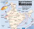
Southwest monsoon, the key to the agriculture driven trillion-dollar Indian economy, on Tuesday brought showers to Kerala bringing much-needed relief to farmers.

The benchmark index on Wednesday surged 314.92 points or 1.05 per cent to close at 30,248.17 on widespread buying spurred by forecast of a normal monsoon this year.

After a stellar run on the bourses that saw tractor stocks rise up to 52 per cent, analysts are turning cautious on the sector as muted demand trends may weigh in the near-term. Total volumes in the tractor segment for the last three quarters of the current financial year (9MFY24) have remained weak with VST Tillers, Escorts Kubota, and M&M seeing declines of 21 per cent, 5 per cent, and 3 per cent year-on-year (Y-o-Y), respectively, during the period, amid patchy rainfall, delayed crop harvest, and lower reservoir level. Across industry, total domestic sales volume so far in the current financial year (April '23 to January '24) has declined 5 per cent Y-o-Y, as per Tractor Manufacturers Association (TMA).

The finance ministry on Thursday raised concerns over the possible impact of El Nio conditions on India this year, saying if recent forecasts came true, the country could see lower agricultural output and higher inflation. "Some meteorological agencies predict the return of El Nio conditions in India this year. "If these predictions are accurate, then monsoon rains could be deficient, leading to lower agricultural output and higher prices," the ministry said in its monthly economic review.

The Navy has has kept five flood teams and three diving teams on stand-by in Mumbai, the official said. These teams, trained and equipped for rescue operations, are stationed at various naval areas across Mumbai and can provide early response over a larger area, he said.

The IMD DG said there should not be an impression that climate change leads to rise in the temperature, but on the contrary, it leads to erratic weather.

Cyclone 'Biparjoy', the first storm brewing in the Arabian Sea this year, has rapidly intensified into a severe cyclonic storm, with meteorologists predicting a 'mild' monsoon onset over Kerala and 'weak' progress beyond southern peninsular under its influence.

El Nino, an anomalous rise in sea surface temperature off the Peru coast, has been observed to often cause the Indian monsoon to flounder, resulting in poor rainfall. Nearly 60 per cent of agricultural land is wholly rain-dependent.

The very severe cyclonic storm 'Biparjoy' intensified into an 'extremely severe cyclonic storm' and is likely to cross Saurashtra-Kutch and adjoining Pakistan coasts around the afternoon of June 15 as a 'very severe cyclonic storm (VSCS)', the India Meteorological Department said on Sunday.

India is likely to experience below-normal monsoon rainfall this year, with a 20 per cent chance of drought due to the end of La Nina conditions and the potential for El Nino to take hold, private forecasting agency Skymet Weather said on Monday.

A red alert has been sounded in three districts of Idukki, Thrissur and Palakkad in Kerala.

Heavy rainfall and high speed wind has badly affected normal life in Bihar in last 24 hours because of cyclonic storm Phailin impact of cyclonic storm. "More heavy rains are expected in Bihar in next 24 hours," a met department official said.
Senior officials of the India Meteorological Department said they were now more confident that El Nino would indeed appear during the second half of the southwest season, compared to April when the last official forecast was made.

A well-marked low-pressure area over southwest Bay of Bengal intensified into a depression on Thursday morning packing wind speed of 40-50 kmph as it moved towards the north Tamil Nadu coast, the weather office said.

Above-normal heatwave days are predicted in most parts of central, east and northwest India during this period.

The poisonous haze has been causing significant problems for people with existing respiratory issues, according to doctors.
Taking a lesson from last year's tsunami disaster, sensors are being planted in the seabed to record seismological changes, according to the Indian Space Research Organisation.
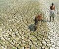
Taking a sceptical view of MUDRA program, Shiv Sena sought to know when the distressed farmers get help and how does the government plan to curb their suicides.
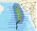
'Very severe cyclonic storm Biparjoy at 2330 hrs IST of 9th June over east-central Arabian Sea near lat 16.0N & long 67.4E. Likely to intensify further & move north-northeastwards during the next 24hrs,' the IMD said in a tweet.

The India Meteorological Department has said that the landfall process of Cyclone 'Biparjoy' has started in Saurashtra and Kutch regions of Gujarat. The landfall process will carry on till midnight with wind speeds reaching a maximum of 140 kilometres per hour, the IMD said.

Data spanning the years 1951 to 2014 show that temperature and pressure conditions at specific locations in the Arctic region during the pre-monsoon period correlate with the Indian summer monsoon rainfall, points out Charu Bahri.
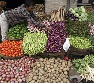
The CII has suggested a 5-point agenda on the measures that need to be undertaken by central and state governments to stave off the adverse effects of a deficient monsoon. Let's find out what this agenda is. . .

Officials in the weather department said the monsoon is expected to be below normal because of the El-Nino effect.

The country can expect normal rainfall during the southwest monsoon season as a positive Indian Ocean Dipole (IOD) and a lower snow cover over the northern hemisphere are likely to counter the evolving El Nino conditions, the India meteorological department (IMD) said on Tuesday.
Though early days, meteorologists point towards a neutral La Nina during the initial phase of the four-month monsoon season this year that starts from June. If this holds true, by the time the rains hit the mainland, it could mean there would be one less reason to worry about the prospects of the monsoon this year. Weathermen said making any accurate prediction of how El Nino will behave and what impact it can have on the progress and distribution of rains is difficult to say at this point. A clear picture will emerge around late May or early June.

There has not been a large impact of untimely rain and hailstorm so far in several major wheat-growing areas, and those might have damaged around 3 per cent of the standing crop -- not enough to make a big dent in the expected 112 million tonnes of production in FY24, a senior government official said on Tuesday. Relentless rain pounded most North Indian states all through March. Separately, the chairman of Food Corporation of India (FCI), Ashok K Meena, told reporters the agency was on track to achieve the targeted 34 million tonnes of procurement in FY24 on the back of a strong start to the purchase season from Madhya Pradesh.

'How much rain fell on June 16 and 17 is NOT known because the area of Kedarnath is not covered by the Indian Meteorological Department,' M Shashidhar Reddy, vice chairman of the National Disaster Management Authority tells Sheela Bhatt. Because of this, the NDMA will not know "what exactly happened over there, in and around the Kedarnath temple."

The World Meteorological Organisation/Economic and Social Commission for Asia and the Pacific Panel on Tropical Cyclones, at its twenty-seventh session held in 2000 in Muscat, Oman, agreed to assign names to the tropical cyclones in the Bay of Bengal and Arabian Sea.

The weather system over the South Andaman Sea and the adjoining southeast Bay of Bengal is very likely to move north-westwards and strengthen into a depression by Saturday, the Met Department said.
